Printed from www.AntiqueMapart.com Catalogue on Saturday, Apr 20 2024
Search Criteria:


Showing Maps 21 to 36 of 36Jump to Page:Next12
Australien oder Polynesien
1796
SOTZMANN, D.F
32 x 26 cm

Sotzmann's map of the pacific is a popular German depiction of Australasia. Here Australia can be seen still connected to Tasmania as was believed until Flinder and Bass's discoveries in 1798…[more]

Mappemonde ou Carte Reduite des Parties Connves du Globe pour fervir au Voyage de la Perouse fait dans les Annees 1785, 86, 87, 88.
1797
LA PEROUSE
92 x 59 cm

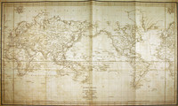
Map of the world showing the route of La Perouse's voyage. Cook's 1770 first voyage discoveries on Australia's East Coast are charted.

Following the immense success of Captain Cook's…[more]

A Chart Shewing the Tract of Capt Cook's Last Voyage
1799
PAYNE
20 x 25 cm

"A Chart Shewing the tract of Capt Cook’s last voyage 1799", by Low. The map shows the route of Cook’s third voyage around the Pacific rim in search of the fabled Northwest passage. On the…[more]

Chart of the Duff's Track in the Pacific Ocean 1797
1799
WILSON, James, CHAPMAN, T
53 x 34 cm

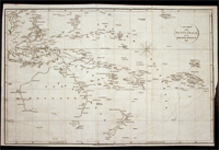
This detailed chart shows the voyage of the Duff in 1797. This map marks and details the route of the first English missionary voyage to the Pacific. Captain James Wilson during the voyage also…[more]

Chart of part of the Fegee ( Fiji ) Islands explored by Cap James Wilson, in the ship Duff…
1799
WILSON, James, CHAPMAN, T
23 x 30 cm
Information to…[more]
General-Charte von Australien. Nach den neuesten Entdeckungs-Reisen und astronomischen Bestimmungen…
1803
REINECKE, J.M.
60 x 45 cm

Information to…[more]

A chart of the Indian Ocean improved from the chart of M. D'Apres De Mannevillette; with the addition of a part of the Pacific Ocean…
 	 A chart of the Indian Ocean improved from the chart of M. D'Apres De Mannevillette; with the addition of a part of the Pacific Ocean…
1803
DE LA ROCHETTE, Louis Stanislas d'Arcy, FADEN, William
110 x 58 cm

De La Rochette's beautiful chart encompassing the Indian Ocean, Australasia and the Pacific is best appreciated up close. The quality of the engraved image and high level of detail is of a…[more]

Generalcharte von Australien nach dem entwurfe des H.Joseph Marx Freiherrn v. Liechtenstern
1805
SWOBODA & HARTL
67 x 50 cm

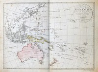
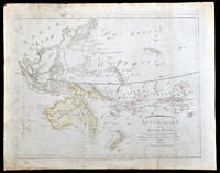
In 1805 when this map was printed there was a strong belief that the Australian continent may be divided by an internal sea so that the east coast was separated from the rest of the …[more]

Charte von Australien oder Polynesien…
1809
ANONYMOUS
35 x 30 cm

Information to come…[more]

Australien nach den neusesten astronomischen Bestimungen und Entdeckungs Reisen
1810
MOLLO, Tranquillo
45 x 32 cm

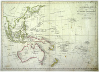
From the Viennese engraver Mollo. This map shows the popular depiction of the region including much of the South Pacific, South East Asia, New Zealand, and Australia. Australia is labeled "Neu…[more]

Karte von Australien
1810
WALCH, Johann
22 x 18 cm

Information to…[more]

Australien oder die Insel Welt
1815
KIPFERLING, Karl Joseph
40 x 31 cm

Austrian map of the Australasian…[more]

Charte von Australien, nach den neuesten und besten Hülfsmitteln entworfen und gezeichnet…
1817
STREIT, Friedrich Wilhelm, DREYKORN, C.R.
65 x 48 cm

Streit’s map of Australia and the Pacific is executed with an excellent quality of engraving. Streit most likely takes inspiration from Swoboda and Hartls map of ‘Australien’ of 1805, as much of…[more]

Australian (Sudland) auch Polynesien oder Inselwelt...
1820
WALCH, Johann
48 x 60 cm

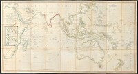
Walch's map of the Pacific comes after most of the major coastal charting of the region has been made though of course in the case of Australia a vast majority of the interior is still unexplored…[more]

Carte de l’Oceanie ou cinquieme partie du monde
 Carte de l’Oceanie ou cinquieme partie du monde
1821
BRUE, Adrian
49 x 35 cm

Information to…[more]

Oceanie
Oceanie
1852
LEVASSEUR, Victor
42 x 30 cm

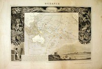
A beautiful map of the Australian region and Pacific. The map is surrounded by a very decorative border depicting scenes from the Pacific.

This map comes from one of the last ornate…[more]