

Six parts of the Eight Volumes of Valentyn's (Valentijn) rare work printed between 1724 and 1726. More information to come.
…[more]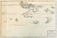
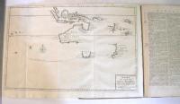
This map is included with Volumes 1 to 4 of Valentyn's rare work printed between 1724 and 1726. The map shows the track of Tasman's epic first voyage to Australia in 1642-43.
Also…[more]
.jpg)
Map of Tasmania showing the track of Abel Tasman's first voyage of 1642-43, which resulted in the discovery of Tasmania and New Zealand.
Apart from the very rare copy of Vissher's map,…[more]
The first large-scale map of Australia by an Englishman showing the 1642-43 and 1644 discoveries of Abel Tasman in Australia and New Zealand .
Despite the fairly rapid and wide…[more]
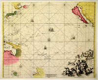
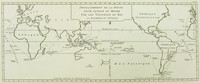
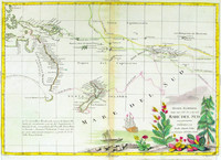
Sea chart of the Pacific, filled with some of the most famous cartographic misconceptions. California is an island; the northen coastline of Australia is shown, with Tasmania a long way away from…[more]

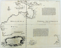
One of the few 18 th century maps concentrating on the Australian continent and showing the east coast joined from New Guinea to Tasmania .
This chart of Australia exemplifies French…[more]
.jpg)
One of the few 18 th century maps concentrating on the Australian continent and showing the east coast joined from New Guinea to Tasmania .This piece comes from the Dutch edition which has both…[more]
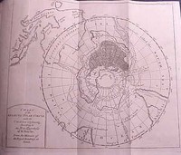
A very interesting map of the southern hemisphere focusing on the southern pole and Australia. This is the English edition of Buache's map which theorizes on the shape of the Antartic landmass.…[more]
.jpg)
One of a number of variations of the this map. The eastern hemisphere has Australia depicted with the classic exagerated eastern coastline especially used by the French pre-Cook. The map is…[more]
The first depiction of any part of Australia 's east coast based on actual observation. This map shows the tracks of Bougainville 's ships the Boudeuse and L'Etoile around the world in 1766 - 1769…[more]
.jpg)
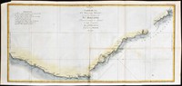
The first published chart of the east coast of Australia .
The first published full-scale map of the east coast of Australia and it is based on the charts drawn by Cook during the…[more]
.jpg)
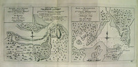
The first published chart of Botany Bay and the Endeavour River after the original drawing by Cook himself and published in the official account of Cook's first voyage.
This map was…[more]
 IH53.jpg)
Believed by many to be the first published chart of the Pacific to show Australia 's east coast and both the north and south islands of New Zealand . Cook's first voyage track is charted.
…[more].jpg)
Sectional map of the north coast of Queensland showing the Endeavour River, where Cook repaired his boat after being shipwrecked.
Cook's bark, the 'Endeavour' encountered little trouble…[more]
This is the first French edition of the first published chart of the east coast of Australia . As was often the case at the time and because of the popularity and importance of Cook's discoveries…[more]

A reduced version of Dalrymple's chart, this map shows the tracks of many explorers including Tasman, Schouten, Mendana, Quiros, Torres and Roggevin. Of particular interest is the track of Torres,…[more]
These charts are from the French/German edition of Captain Cook's visit and charting of Botany Bay and the Endeavour River after the original drawing by Cook himself and published a year after the…[more]
Map of Australia , New Zealand , New Guinea and the South Pacific. One of the earliest maps to show the tracks of the voyages of Capt. Cook, Carteret, Byron, Wallis and Mouats.
Zatta's…[more]
.jpg)
A French chart of Australia and New Zealand showing the discoveries made by Cook in 1770, during his first voyage and the discoveries made by Capt. Furneaux in Tasmania in 1773. Australia is…[more]
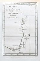
The first edition of the first separately printed English map to show part of the coast of Tasmania. Furneaux's track in the Adventure is shown.
In this English edition, this is the…[more]