Printed from www.AntiqueMapart.com Catalogue on Tuesday, Mar 19 2024
Search Criteria:


Showing Maps 41 to 60 of 220Jump to Page:Next12345 ... 1011Next
Southern hemisphere: shewing the track of his Majesties ship Sirius from the Equator to the compleating the circle
1793
HUNTER, John
23 x 20 cm

A small chart of the southern hemisphere that shows the track of HMS Sirius on her voyage out from England in 1787 as the flagship to the First Fleet. The First Fleet was made up of eleven ships…[more]

Australia
Australia
1851
TALLIS, John
33 x 25 cm

Information to…[more]

GEOGRAPHIA ET ASTRONOMIA
1740
RICHTER, STEINBURGER
26 x 22 cm

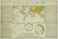
A beautiful map focusing on astrological interests including the orbits of the planets.…[more]

Carte de L'Hemisphere Austral
1778
COOK, James, BENARD
53 x 54 cm

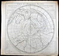
A French edtion of Captain James Cook's famous chart of the Southern Hemisphere. The original English edition was printed in 1777 when Cook's second voyage was published. The French edition was…[more]

Carte de l’Oceanie ou cinquieme partie du monde
 Carte de l’Oceanie ou cinquieme partie du monde
1821
BRUE, Adrian
49 x 35 cm

Information to…[more]

No title: Region around Sydney
1802
COLLINS, David
24 x 19 cm

An interesting map of the interior around Sydney. In the early days of the settlement in Australia there was a prime importance to establish sufficient even abundent food supplies so that the…[more]

Australia
Australia
1844
JOHNSTON, A.K
61 x 50 cm

By 1844 the extent of explored regions in Australia was still generally minor in relation to the size of the continent. The gold rushes were yet to have begun and only the small colonies on the…[more]

Carte d'une partie du Grand Ocean
1797
LA PEROUSE
49 x 34 cm

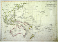
Map focusing on the present day Queensland coast, New Guinea, and part of the Pacific. Shown is the 1781 route of Spanish explorer Don Francisco Antonio Maurelle along the northern coast of New…[more]

Räths Physikalischer Erdglobus ; 1:38 600 000
1950
RÄTH, Paul
34 x 52 cm

Rath's firm was located in Leipzig, Germany, a city known for its publishing houses. Rath established the firm in 1917 and from 1921 also produced electric illuminated globes. His globes from a…[more]

Eastern Hemisphere
Eastern Hemisphere
1851
TALLIS, John
28 x 36 cm

Tallis' very decorative map of the eastern hemisphere.…[more]

Norfolk Island/ S.End of Norfolk Island
1789
STOCKDALE, J
46 x 43 cm

Stockdale's map of Norfolk Island is the first map of the settlement of the new colony. The top half of the map shows an overview of Norfolk and the two outlying islands, Phillip and Nepean. The…[more]

A Chart of Captn Carterets Discoveries at New Britain, with part of Captn Cooks passage thro Endeavour Streights…
1773
COOK, James
63 x 22 cm

Captain Cooks chart of New Guinea showing also previous exploration by other explorers such as Carteret. A very nice large chart of the island

Captain James Cook (1728-1779) was an…[more]

Carte de L'Australie
1826
BRUE, Adrian
51 x 36 cm

Brue had a special relationship with Australia. He was involved in Baudin's expedition between 1801 and 1803 which charted the Australian coastline. The discoveries from the expedition would…[more]

The World in Hemispheres, with comparitive views of the heights of the principal Mountains and lengths of the principal Rivers on the Globe.
1844
JOHNSTON, A.K
65 x 53 cm

A brilliant later world map that also shows the comparitive heights of the highest mountains and lengths of the longest rivers. From Johnston's 'National Atlas' the map is a fine example of his…[more]

Australien nach den neusesten astronomischen Bestimungen und Entdeckungs Reisen
1810
MOLLO, Tranquillo
45 x 32 cm

From the Viennese engraver Mollo. This map shows the popular depiction of the region including much of the South Pacific, South East Asia, New Zealand, and Australia. Australia is labeled "Neu…[more]

Charte von Australien oder Polynesien…
1809
ANONYMOUS
35 x 30 cm

Information to come…[more]

Map of Van Diemans Land; Map of part of New South Wales
1824
LIZARS, Daniel
50 x 35 cm

Two maps by Lizars on the one sheet. One focuses on Van Diemens Land (Tasmania) and the limit of interior exploratioin, most notably connecting the northern and southern coastlines. There is also…[more]

Entrée De La Riviere Endeavour... / Baye De Botanique…
1774
COOK, James
33 x 13 cm

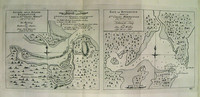
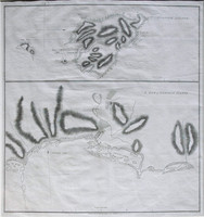
These charts are from the French/German edition of Captain Cook's visit and charting of Botany Bay and the Endeavour River after the original drawing by Cook himself and published a year after the…[more]

Neue Karte von Europa, Asia, Africa, und America: welche vor nehmlich den Handel der Europaer mit den Vorzuglichsten Kunst und Natur Producten dieser Lander enthalt
1785
ANONYMOUS
62 x 41 cm
Information to…[more]
Chart of Cook's Strait in New Zealand
1773
COOK, James
27 x 27 cm

From James Cook's first voyage in which he charted New Zealand and the east coast of Australia. The map depicts Cook's Strait, that seperates the north and south island of New Zealand. Present day…[more]