Printed from www.AntiqueMapart.com Catalogue on Saturday, Apr 20 2024
Search Criteria:


Showing Maps 81 to 100 of 245Jump to Page:Next1234567 ... 1213Next
Isle Norfolk
Isle Norfolk
1778
COOK, James, BENARD
19 x 22 cm

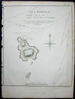
The first map of Norfolk Island, which was discovered in 1774. The first edition of this map was included in James Cook's second voyages published in 1777. Because of Cook’s voyages wide…[more]

Mappe Monde ou Carte Generale de l’Univers
1778
LOTTER, Tobias
90 x 46 cm

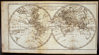
Lotter's map of the world in ovaloid projection shows the track of Cook's first voyage.The later editions of the map continued to update the map especially using Cook's discoveries.

Even…[more]

Carte Generale De Toutes les Parties Connues De La Surface De La Terre, En Carte Redutte.
1780
BONNE, Rigobert
34 x 24 cm

Shows the world on Mercators…[more]

L'Ancien Monde et Le Nouveau en Deux Hemipheres
1780
BONNE, Rigobert
41 x 22 cm

A popular map of the world still showing Australia connected to Tasmania. Bonne produced a large body of work though usually not very decorative like this piece.…[more]

Carte de la Nouvelle Zeelande
1780
BONNE, Rigobert
22 x 33 cm

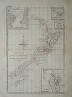
Bonne's chart of New Zealand is among the first maps produced of the Islands, being a representation of Cook's 1773 charts. Bonne essentially copied a number of Cook's charts for his atlas and…[more]

Mappe Monde sur le plan de L'Equateur, Hemisphere Meridional
1780
BONNE, Rigobert
34 x 24 cm

This map of the southern hemisphere by Bonne is one of 4 that show the North, South, East, and West…[more]

Mappe Monde sur le plan D'un Meridien. Hemisphere Oriental
1780
BONNE, Rigobert
34 x 24 cm

This map is one of 4 that depicts the North, South, East and West…[more]

Scientia Terrarum et Coelorum or the Heavens and Earth Astronomically and Geographically Dilineated and Displayed
1781
DUNN, Samuel
120 x 104 cm

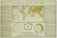
Wall map of the world. Shows mathematical calculations for astronomy, navigation. Discusses many mathematical issues.

Published: 1781.

About the Publishers: Published by Robert…[more]

Mappe Monde ou Carte Generale de l’Univers
1782
LOTTER, Tobias
90 x 46 cm

Lotter's map of the world in ovaloid projection showing the tracks of Cook's three voyages of discovery.

It is one of the first large scale maps to show the discoveries of Cook's three…[more]

A General Chart: Exhibiting the Discoveries made by Capt.n James Cook in this and his two preceeding Voyages with the Tracks of the Ships under his Command
1784
COOK, James, ROBERTS, Henry
92 x 58 cm

This map is the centrepiece to the Cook collection and is said to have been the most accurate map of the world on its publication in 1784.

The map was drawn up by Henry Roberts after work…[more]

Neue Welt Karte…
Neue Welt Karte…
1784
HOMANN HEIRS
56 x 47 cm

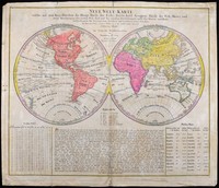
A map of the world showing Cook's second and third voyages. Australia is shown fairly crudely due to the maps purpose of showing the six regions or continents in the world. North America, South…[more]

Atlas ; A Voyage to the Pacific Ocean
1784
COOK, James
55 x 38 cm

Cook's famous folio atlas to his 3rd voyage containing 62 engravings including the rare Death of Cook plate plus two large charts showing the extent of Cook's exploration during his three voyages…[more]

Chart of Van Diemen's Land
1784
COOK, James, BLIGH, William
35 x 22 cm

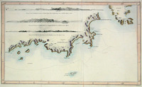
James Cook & William Bligh's map of part of the southern coast of Tasmania, formely Van Diemen's land. The charting was carried out during Cook's third voyage during which he was killed in Hawaii…[more]

Neue Karte von Europa, Asia, Africa, und America: welche vor nehmlich den Handel der Europaer mit den Vorzuglichsten Kunst und Natur Producten dieser Lander enthalt
1785
ANONYMOUS
62 x 41 cm
Information to…[more]
An account of the voyages undertaken by the order of his Majesty for making Discoveries in the Southern Hemiphere…
1785
HAWKESWORTH, John
22 x 14 cm

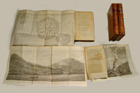
The third edition of Cook's famous voyage in which the East Coast of Australia and most of New Zealand was discovered and charted. There are 4 volumes in total in an octavo format. Unlike the…[more]

MAPPE MONDE CELESTE TERRESTRE ET HISTORIQUE... BRION DE LA TOUR
MAPPE MONDE CELESTE TERRESTRE ET HISTORIQUE...
  BRION DE LA TOUR
1786
BRION DE LA TOUR
105 x 93 cm

Magnificent wall world map in twin hemispheres showing the discoveries made by Cook in 1770 in New Zealand and Australia. The whole map set within a splendid and impressive framework.

…[more]
A General Chart of the Passage from England to Botany Bay in New Holland 1787
1787
ANDREWS, J.
39 x 26 cm

Though this appears to be a map of the world it’s actual objective is to illustrate Australia’s (New Holland) distance from England and the track that is planned to be taken by the First Fleet on…[more]

Nlle galles Merid.le ou Cote Orientale de la Nouvelle Hollande
1787
BONNE, Rigobert
22 x 33 cm

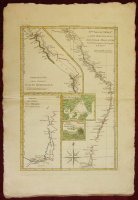
Bonne's map of Australia's east coast combines a number of James Cook's maps onto the one, in a kind of consolidation often used by Bonne. The map shows Australia's east coast, an inset of part of…[more]

Isles des Nouvelles Hebrides et celle de La Nouvelle Caledonie
1787
BONNE, Rigobert
3 x 2 cm

Bonne's map shows a number of islands in the Western South Pacific that were originally charted by Cook during his three voyages. The central focus are the islands of New Caledonia and the New…[more]

The History of New Holland, from its First Discovery in 1616, to the Present Time… with a Particular Account of its Produce and Inhabitants; and a Description of Botany Bay...An Introductory Discourseon Banishment
1787
EDEN, STOCKDALE, J

THE HISTORY OF NEW HOLLAND, from its First Discovery in 1616, to the Present Time. With a Particular Account of its Produce and Inhabitants; and a Description of Botany Bay: also, A List of the…[more]