Contact: contact@AntiqueMapArt.com, Phone: +61 (07) 3103 0391, Mobile: 0011 6723 51512 (Norfolk Mobile)
_0.jpg)
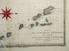
1787 - Isles des Nouvelles Hebrides et celle de La Nouvelle Caledonie
| Map maker | Size | Map ID | Condition |
| Rigobert Bonne | 33 x 23 mm | D1 / M232 / I357 | Please contact us for a full condition report |
| Ask about this item |
Bonne's map shows a number of islands in the Western South Pacific that were originally charted by Cook during his three voyages. The central focus are the islands of New Caledonia and the New Hebrides (Vanuatu). Norfolk Island is shown as an inset map in the top left corner.
View map online on http://www.antiquemapart.com/map/232


