Contact: contact@AntiqueMapArt.com, Phone: +61 (07) 3103 0391, Mobile: 0011 6723 51512 (Norfolk Mobile)

1863 - Proeschel's Atlas of Australasia
| Map maker | Size | Map ID | Condition |
| Frederick Proeschel | 0 x 0 mm | D1 / M354 / I328 | Excellent condition with orginal blue binding. Please contact us for a complete condition report |
| Ask about this item | | SOLD |
Evidence continues to imerge that points to Proeschel's atlas being the first national atlas to be printed in Australia. William Baker did publish 'The Australian County Atlas' in Sydney in 1843, however this focuses primarily on the counties of the east coast and does not necessarily conform to the traditional form of an atlas. This makes Proeschel's very rare atlas particularly special and in the coming years its importance and desirability will continue to grow. Ronald Tooley who was an authority on Australian maps and compiled 'The Mapping of Australia' in 1979 was initially unaware of the atlas, showing the degree of its rarity and the reason it is not well known.
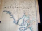
Contained inside the atlas are five large and impressive maps of NSW, Victoria, Queensland, North Australia or Albert land (NT) and South Australia. There are also two smaller maps showing the world and Australasia. The maps of the colonies were compiled using government maps from the time but also observations made by Proeschel himself, his associates, and information that was arriving in Melbourne at the time. This gives the maps an additional depth not seen on government issued maps. Preceding each map is a statistical table detailing information about each colony except for Queensland, which would have only been recently formed (1859).
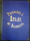
This very rare atlas is bound in original half blue Morocco with "Proeschel's atlas of Australia" ornately tooled in gilt on the front cover. A superb example of an almost unacquirable atlas.
Proeschel was born in France in 1809 and moved out to Victoria to participate in the gold rushes in 1852. Basing himself in Melbourne he set about producing maps of routes to the goldfields as well as general maps of Victoria and Melbourne. Proeschel was the only private map publisher in Victoria at the time and so was able to produce a varied collection of work compared with what was available. In may 1860 he became a member of the Royal society of Victoria. By 1863 he produced his famous "Atlas of Australasia", though it is believed that he was unlikely to have recouped his sizable £3000 investment in its publication, even though it received much acclaim. He left Australia in 1864 and after pursuing a few opportunities settled again in France before his death in 1870 leaving an estate of a mere 40 francs.
View map online on http://www.antiquemapart.com/map/354


