Contact: contact@AntiqueMapArt.com, Phone: +61 (07) 3103 0391, Mobile: 0011 6723 51512 (Norfolk Mobile)
_0.jpg)
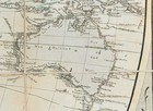
1814 - Erd Charte nach der Bonneschen Projection...
| Map maker | Size | Map ID | Condition |
| Heinrich Keller | 1000 x 600 mm | D1 / M388 / I365 | Very good condition with minor foxing on canvasbacking |
| Ask about this item | | SOLD |
A beautiful large world map by Austrian mapmaker Heinrich Keller. Interestingly as this map was printed early in 1814 the detail of Australia shows a pre Flinders Australia with the French claim from the Baudin voyage naming the south east region of Australia Napoleons Land with spencers gulf also being named Bonapartes Gulf. By the end of 1814 almost all maps would be corrected to reflect the English's first discovery and charting of this region under Flinders and this interesting part of Australia's French claim history that existed between 1811 and 1814 would end.
View map online on http://www.antiquemapart.com/map/388
.jpg)
.jpg)


.jpg)
