Printed from www.AntiqueMapart.com Catalogue on Wednesday, May 01 2024
Search Criteria:


Showing Maps 161 to 180 of 245Jump to Page:Next12 ... 78910111213Next
Chart of Terra Australis,by M. Flinders, Commr. Of H.M. Sloop Investigator. 1798-1803. East Coast Sheet 1 (Sydney NSW coast)
1814
FLINDERS, Matthew
42 x 60 cm

Matthew Flinders (1774-1814) was an accomplished navigator and cartographer, having circumnavigated the Australian continent, proved that Tasmania was not joined to the mainland, and played a…[more]

Views on the South Coast of Terra Australis. Plate XVII
1814
WESTALL, William, FLINDERS, Matthew
48 x 72 cm

These 7 views of the coastline between Cape Leeuwin in Western Australia to Cape Wiles in South Australia are an interesting and important relic from Flinders famous journey during the…[more]

Chart of Terra Australis. Sheet II, East coast (Byron Bay , Brisbane )
1814
FLINDERS, Matthew
41 x 59 cm

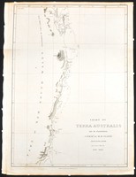
Offered here is the very rare and desirable first edition of Flinders exceptional and important chart, printed before the death of Flinders and before the admiralty would begin to publish the…[more]

Chart of Terra Australis. Sheet VI, South coast ( Tasmania )
1814
FLINDERS, Matthew
63 x 43 cm

Flinders chart of Van Diemen's land from his first edition of the chart issued before the event of his death in the same year (1814). This example comes from the much rarer elephant folio that…[more]

Chart of Terra Australis. Sheet III, South coast (Spencers Gulf, South Australia)
1814
FLINDERS, Matthew
89 x 60 cm

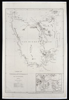
Flinders chart of Spencer’s Gulf and the Gulf of St Vincent is important for a number of reasons. This chart’s cartographic importance to the knowledge of the coastlines of Australia is in the…[more]

Chart of Terra Australis. Sheet III, East coast (South Queensland, Fraser Island)
1814
FLINDERS, Matthew
89 x 60 cm

The rare first edition chart by Matthew Flinders printed before the admiralty began publishing the chart. Shown is the Queensland coast between Wide Bay (near Noosa Heads) and the Flat Isles…[more]

Tracks of Anson, Byron, Wallis & Carteret; with Cook's in 1769
1814
BLACKWOOD, William
20 x 36 cm

Blackwood's map of the Southern Pacific is based on James Cook's 1773 chart of the same area. In this case the map was produced to be included in "Kerrs collection of voyages and travels". As…[more]

Chart of Terra Australis...East Coast Sheet IV, (Great Barrier Reef, Central/ Northern Queensland)
1814
FLINDERS, Matthew
62 x 89 cm

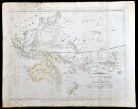
Flinders' chart in his ship the 'Investigator' (1802) of the central/northern Queensland coast shows the region between Cape Manifold and Cape Grafton as charted by both Cook and Flinders.…[more]

New Holland and Asiatic Isles
1814
THOMSON, John
62 x 50 cm

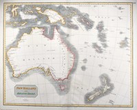
In 1814 Matthew Flinders printed his account of his discovery and charting of the Southern coastlines of Australia shortly before he died. This map printed the same year as flinders’ is an…[more]

Erd Charte nach der Bonneschen Projection...
1814
KELLER, Heinrich
100 x 60 cm

A beautiful large world map by Austrian mapmaker Heinrich Keller. Interestingly as this map was printed early in 1814 the detail of Australia shows a pre Flinders Australia with the French claim…[more]

Australien oder die Insel Welt
1815
KIPFERLING, Karl Joseph
40 x 31 cm

Austrian map of the Australasian…[more]

To the officers in the Honorable East India Company's service this outline chart...
1815
HEATHER, William, WALLIS, James
120 x 64 cm

This rare chart by Heather belonged to Major (Captain) James Wallis of the 46th Regiment, who was responsible for the early building of Newcastle (NSW) and also one of the early artists to…[more]

Charte von Australien, nach den neuesten und besten Hülfsmitteln entworfen und gezeichnet…
1817
STREIT, Friedrich Wilhelm, DREYKORN, C.R.
65 x 48 cm

Streit’s map of Australia and the Pacific is executed with an excellent quality of engraving. Streit most likely takes inspiration from Swoboda and Hartls map of ‘Australien’ of 1805, as much of…[more]

Le Sage's Historical, Genealogical, Chronological and Geographical Atlas…
1818
LE SAGE
39 x 51 cm

The English edition of Le Sage's impressive French folio atlas. This is the second English edition and is updated until 1818. Its title page notes "Second Edition improved with a new Geographical…[more]

East India Isles & Australia
1819
WYLD, James
28 x 22 cm

Information to…[more]

A Chart of Part of the Interior of New South Wales. By John Oxley Surveyor General. 1818. Second Expedition
1820
OXLEY, John
61 x 20 cm

Focusing on Oxley's route during his second expedition through the central part of New South Wales along the Macquarie river. From the Macquarie Marshes it continues eastwards across the western…[more]

A Plan of Port Macquarie including a sketch of part of Hastings River...
1820
OXLEY, John
65 x 23 cm

Oxley's chart of Port Macquarie and part of the course of the Hastings River for about 17 miles upstream including depth soundings. Initially it was thought that the Hastings would be ideal for…[more]

Australian (Sudland) auch Polynesien oder Inselwelt...
1820
WALCH, Johann
48 x 60 cm

Walch's map of the Pacific comes after most of the major coastal charting of the region has been made though of course in the case of Australia a vast majority of the interior is still unexplored…[more]

MappeMonde Revue et Corrigee
1820
ANONYMOUS
40 x 26 cm

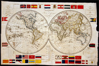
An early world map from 1820 displaying a number of National flags. It is interesting to see how many flags have since changed their design, though the Union Jack is still much as it was in…[more]

Carte de l’Oceanie ou cinquieme partie du monde
 Carte de l’Oceanie ou cinquieme partie du monde
1821
BRUE, Adrian
49 x 35 cm

Information to…[more]