Printed from www.AntiqueMapart.com Catalogue on Monday, Apr 29 2024
Search Criteria:


Showing Maps 101 to 120 of 245Jump to Page:Next12 ... 45678 ... 1213Next
Death of Captain Cook
1787
CLEVELEY, John
51 x 66 cm

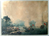
Cleveley's aquatint of the Death of Cook is among the best of the events depictions. In the fashion of aquatints at first glance it appears that the print is actually a watercolour.

…[more]

A New Chart of New Holland on which are delineated New South Wales, and a plan of Botany Bay
1787
ANDREWS, J.
35 x 36 cm

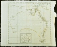
An exceptional chart of Australia and one of the very few pre settlement maps that focus exclusively on the Australian continent. This rare piece was included in the important book "The history of…[more]

A chart of the track of the Alexander on her homeward passage from Port Jackson on the eastn. coast of New South Wales to Batavia; performed in the year 1788 under the direction of Lieut.t John Shortland
1789
SHORTLAND, Thomas G.
35 x 26 cm

The Alexander was one of the eleven ships that made up the first fleet which settled the English in Australia in January 1788. The 450- ton convict transport ship transported around 200 convicts…[more]

A chart of Lord Howe Island discover’d by Lieut. Henry Lidgbird Ball in His Majesty’s Arm’d Tender Supply on the 17th of Feb.y 1788
1789
BALL, Henry Lidgbird
33 x 26 cm

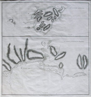
This chart is the first of the beautiful world heritage Australian Island of Lord Howe. Lord Howe was discovered by Ball on his journey to set up a second English settlement on Norfolk Island. The…[more]

Plan of Port Jackson New South Wales ... 1788 by Capt John Hunter;
1789
HUNTER, John
41 x 27 cm

Another very important chart in terms of the English settlement of Australia. This chart was completed by John Hunter shortly after establishing the settlement in Sydney cove in 1788. The First…[more]

A chart of a track of land in the Southern Pacific Ocean…
1789
SHORTLAND, Thomas G.
41 x 38 cm
Information to…[more]
Norfolk Island/ S.End of Norfolk Island
1789
STOCKDALE, J
46 x 43 cm

Stockdale's map of Norfolk Island is the first map of the settlement of the new colony. The top half of the map shows an overview of Norfolk and the two outlying islands, Phillip and Nepean. The…[more]

Sketch of Sydney Cove, Port Jackson in the Country of Cumberland New South Wales July 1788
1789
DAWES, W
48 x 48 cm

This early piece is the first printed map of Sydney Cove, which was made only 6 months after the first fleet arrived in Sydney.

The map focuses on the area of present day Circular Quay,…[more]

A chart of the track of the Scarborough on her homeward passage from Port Jackson on the Et. (East) coast of New South Wales towards China
1789
MARSHALL, Captain John
24 x 42 cm

The Scarborough was one of the ships of the First Fleet, which brought the English to Sydney in January 1788, where they would establish the first English settlement.

, .

This chart shows…[more]

The Voyage of Governor Phillip to Botany Bay; with an account of the establishment of the colonies of Port Jackson & Norfolk Island...
1790
PHILLIP, Arthur
22 x 15 cm

One of the most important books written on the initial settlement of Australia in 1788 with detailed accounts of the people, animals and plants encountered in both Port Jackson and on Norfolk…[more]

A new & accurate chart of the discoveries made by the late Capt. Js. Cook…
1790
BOWEN, Emanuel
33 x 45 cm

Bowen's map of the Pacific is typical of the period. After the success of Cook's voyages in the 1770s the worlds attention was drawn to the Pacific where tales of paradise, danger, and adventure…[more]

Mappe Monde Dresse pour l’Etude de la Geographie…
1790
BRION DE LA TOUR
48 x 28 cm

One of a number of variations of this map. The eastern hemisphere depicts Australia with the classic exaggerated eastern coastline, which was especially used by the French in the pre-Cook era. The…[more]

The Track pursued by Capt. Bligh from the islands of Tofoa to Timor
1790
BLIGH, William
57 x 14 cm

This map charts the voyage of William Bligh after he was set adrift during the mutiny on the Bounty in 1789 and sailed over 6000kms from Tofoa (Tonga) to Bativa (Indonesia). During his voyage he…[more]

New Holland and the adjacent Islands, agreeable to the latest discoveries.
1790
KINCAID
24 x 18 cm

‘New Holland and the adjacent Islands’, 1790 by Kincaid. The map depicts a very early inset map of Port Jackson and Sydney Cove. One of the earliest post settlement maps simply focusing on…[more]

A Collection of Voyages round the World: Performed by Royal Authority. Containing a complete Historical Account of Captain Cook's First, Second, Third and Last Voyages…
1790
COOK, James, ANDERSON, George William
13 x 21 cm

A Collection of Voyages round the World; Performed by Royal Authority. Containing a complete Historical Account of Captain Cooks's First, Second, Third and Last Voyages, undertaken For making New…[more]

A map of all those parts of the territory of New South Wales which have been seen by any person belonging to the settlement established at Port Jackson…
 A map of all those parts of the territory of New South Wales which have been seen by any person belonging to the settlement established at Port Jackson…
1792
DAWES, W
53 x 39 cm

Dawes map of the county of Cumberland in New South Wales is today better known as the Sydney region. The coast between Botany Bay in the south to Broken Bay in the north is shown, which extends…[more]

A Voyage to the South Sea, undertaken by command of His Majesty, for the purpose of conveying the bread-fruit tree to the West Indies, in His Majesty's Ship the Bounty…
1792
BLIGH, William
23 x 30 cm

The voyage of the Bounty would have to be one of the most interesting 18th century voyages undertaken. Its story would inspire three Hollywood epics staring some of its greatest stars.…[more]

Southern hemisphere: shewing the track of his Majesties ship Sirius from the Equator to the compleating the circle
1793
HUNTER, John
23 x 20 cm

A small chart of the southern hemisphere that shows the track of HMS Sirius on her voyage out from England in 1787 as the flagship to the First Fleet. The First Fleet was made up of eleven ships…[more]

Fahrt des Lieut. William Bligh von Tofoa einer der Freundschaftlichen Inseln nach Timor im Jahre 1789 in dem Boote der Bounty
1793
BLIGH, William, SOTZMANN, D.F
54 x 20 cm

This very interesting map charts the voyage of William Bligh after he was set adrift during the Mutiny on the Bounty in 1789. He would then sail over 6000kms from Tofoa (Tonga) to Bativa…[more]

An Historical Journal of the Transactions at Port Jackson & Norfolk Island
1793
HUNTER, John
23 x 29 cm

4to. Complete with all called for engravings and charts. Information to…[more]