


Fries' map is of particular interest as it portrays to some extent, the curr-ent indecision about the nature of the world at that time. America had only been discovered some thirty years earlier…[more]

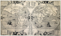
Munster 's world map in ovaloid projection is one of the most sought after sixteenth century maps. Unlike many of its contemporaries, the great southern land is completely omitted.
…[more]
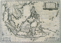
One of the earliest maps of Southeast Asia and published in the first 'modern' atlas. Part of 'Terra Australis Incognita' is shown emerging from the south and is named 'Beach'.
It was…[more]
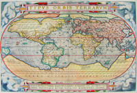
The World map from the first ever published 'modern' atlas. This was to be the prototype of many later world maps. It was to become the standard reference for years to follow. The atlas…[more]
Montanus' map shows the distribution throughout the world of the Noah's sons and their offspring as they re-populated the earth after the great Flood. A numerical and alphabetical reference system…[more]
Map of the world showing a landmass remarkably like the west coast of Australia and roughly where Australia should be.
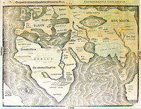
Bunting's map charts a landmass named 'India Meridionalis', which…[more]
.jpg)
The first published map devoted to the Pacific and the most important i6th century map to show the Spanish domination of the South Seas .
Maris Pacifici illustrates the lengths to which…[more]

Ortelius' famous atlas 'Theatrum Orbis Terrarum' was first published in 1570. Regarded as the first 'modern' atlas, it comprised maps of similar size and style. It wasn't until the 1590 edition…[more]
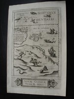
De Jode's rare map of New Guinea and Terra Australis Incognita is considered by some authorities to represent the first printed map of Australia .
One of the remaining contentious issues…[more]

One of the earliest polar maps of the Antarctic.
Of particular interest to historians is the suggestion in the text accompanying this map, which describes rather accurately the…[more]

Solis' map is one of the few world maps to be printed in Spain in the late 16 th and early 17 th centuries. Spain had a strict secrecy policy in connection with the production of maps relating to…[more]

Important map of Southeast Asia and one of the few to show evidence of Drake's contact with Java.
Gerard Mercator is, apart from Ptolemy, probably the most important of all…[more]
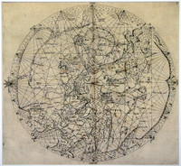
Medieval world map based on Portolano sources, with Jerusalem at the centre and east at the top.
The map is one of the very few printed medieval world maps to be based on Portolano…[more]
.jpg)
The map focuses on Southern Asia and the Northern Pacific, also showing part of the west coast of North America. Part of northern Australia can be seen coloured in green at the bottom of the map.…[more]
.jpg)
The map focuses on Asia. New Guinea is also shown to be divided, showing the strait (Endeavour Strait) that would soon be lost until Cook traveled through it in 1770. It can also be assumed that…[more]
The only Dutch printed map showing the 1606 discoveries of Willem Jansz, who in the Duyfken is attributed as making the first recorded European discovery in Australia on Cape York Peninsula.
…[more]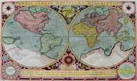
Final state of Jodocus Hondius' rare world map in twin hemispheres surrounded by a decorative strapwork border. This state was published by Le Clerc's widow.
Jodocus Hondius engraved…[more]

The third edition of the first published map to chart the Dutch discoveries in Australia on both Cape York Peninsula and on the west coast of Australia .
Willem Blaeu was Hydrographer to…[more]

Up until 1627, the knowledge of Australian coastlines was restricted to largely haphazard contacts and sightings on the western and northern coasts. The eastern and southern coasts were completely…[more]
.jpg)