Printed from www.AntiqueMapart.com Catalogue on Thursday, May 02 2024
Search Criteria:


Showing Maps 101 to 120 of 159Jump to Page:Next12 ... 45678Next
Views on the South Coast of Terra Australis. Plate XVII (8 to 14)
1814
WESTALL, William, FLINDERS, Matthew
48 x 72 cm

These 7 views of the coastline between Cape Catastrophe in South Australia to Cape Schanck in Victoria are an interesting and important relic from Flinders famous journey during the…[more]

Chart of Terra Australis. Sheet III, South coast (Spencers Gulf, South Australia)
1814
FLINDERS, Matthew
89 x 60 cm

Flinders chart of Spencer’s Gulf and the Gulf of St Vincent is important for a number of reasons. This chart’s cartographic importance to the knowledge of the coastlines of Australia is in the…[more]

Chart of Terra Australis, South Coast Sheet IV
1814
FLINDERS, Matthew
60 x 43 cm

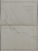
This very rare first edition Flinders chart depicts the region of coast between Melbourne and Adelaide. We will provide a more detailed and in depth description of the map soon.

We have…[more]

Chart of Terra Australis,by M. Flinders, Commr. Of H.M. Sloop Investigator. 1798-1803. East Coast Sheet 1 (Sydney NSW coast)
1814
FLINDERS, Matthew
42 x 60 cm

Matthew Flinders (1774-1814) was an accomplished navigator and cartographer, having circumnavigated the Australian continent, proved that Tasmania was not joined to the mainland, and played a…[more]

A Voyage to Terra Australis; Undertaken for the Purpose of Completing the Discovery of That Vast Country…
1814
FLINDERS, Matthew

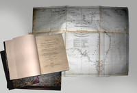
‘A voyage to Terra Australis’ and a ‘General Chart of Terra Australis or Australia’, 1814 by Matthew Flinders. 2 volumes of text and atlas. The Atlas contains 16 charts, 2 coastal views and 10…[more]

Chart of Terra Australis by M. Flinders, Commr. Of H.M. Sloop Investigator, South Coast Sheet V 1798, 1802 & 3 (Bass Strait, Melbourne, Victoria)
Chart of Terra Australis by M. Flinders, Commr. Of H.M. Sloop Investigator, South Coast Sheet V 1798, 1802 & 3  (Bass Strait, Melbourne, Victoria)
1814
FLINDERS, Matthew
89 x 61 cm

First edition of Flinders' important and desirable chart of Bass Strait. More information to come

Matthew Flinders (1774-1814) was an accomplished navigator and cartographer, having…[more]

To the officers in the Honorable East India Company's service this outline chart...
1815
HEATHER, William, WALLIS, James
120 x 64 cm

This rare chart by Heather belonged to Major (Captain) James Wallis of the 46th Regiment, who was responsible for the early building of Newcastle (NSW) and also one of the early artists to…[more]

Australien oder die Insel Welt
1815
KIPFERLING, Karl Joseph
40 x 31 cm

Austrian map of the Australasian…[more]

Charte von Australien, nach den neuesten und besten Hülfsmitteln entworfen und gezeichnet…
1817
STREIT, Friedrich Wilhelm, DREYKORN, C.R.
65 x 48 cm

Streit’s map of Australia and the Pacific is executed with an excellent quality of engraving. Streit most likely takes inspiration from Swoboda and Hartls map of ‘Australien’ of 1805, as much of…[more]

East India Isles & Australia
1819
WYLD, James
28 x 22 cm

Information to…[more]

Australian (Sudland) auch Polynesien oder Inselwelt...
1820
WALCH, Johann
48 x 60 cm

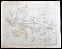
Walch's map of the Pacific comes after most of the major coastal charting of the region has been made though of course in the case of Australia a vast majority of the interior is still unexplored…[more]

A Chart of Part of the Interior of New South Wales. By John Oxley Surveyor General. 1818. Second Expedition
1820
OXLEY, John
61 x 20 cm

Focusing on Oxley's route during his second expedition through the central part of New South Wales along the Macquarie river. From the Macquarie Marshes it continues eastwards across the western…[more]

A Chart of New South Wales, Van Diemen's Land, & C.
1821
ASPIN, J.
60 x 50 cm

Aspin's chart shows inset maps of Tasmania, the settlements at Port Jakson and Patterson's river, and of the Australian continent, marked 'New Holland'.

A very nice map showing the…[more]

Carte de l’Oceanie ou cinquieme partie du monde
 Carte de l’Oceanie ou cinquieme partie du monde
1821
BRUE, Adrian
49 x 35 cm

Information to…[more]

Map of Van Diemans Land; Map of part of New South Wales
1824
LIZARS, Daniel
50 x 35 cm

Two maps by Lizars on the one sheet. One focuses on Van Diemens Land (Tasmania) and the limit of interior exploratioin, most notably connecting the northern and southern coastlines. There is also…[more]

Carte de L'Australie
1826
BRUE, Adrian
51 x 36 cm

Brue had a special relationship with Australia. He was involved in Baudin's expedition between 1801 and 1803 which charted the Australian coastline. The discoveries from the expedition would…[more]

Oceanique. Partie de la Nlle Hollande (Western Australia)
1827
VANDERMAELEN, Philippe
40 x 43 cm

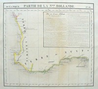
Vandermaelen's map of south western Western Australia encompasses the coastline between Jurien Bay to Cape Le Grand and is listed as Plate number 52 from the Atlas Universal. On the map is an…[more]

Chart of part of New South Wales, with plans of the harbours...respectfully dedicated to John Oxley...
1829
CROSS, Joseph
93 x 61 cm

Joseph Cross' map of New South Wales is one of the earliest detailed and most comprehensive of interior New South Wales. It was originally issued in 1826 and at that time also had a decorative…[more]

THE FRIEND OF AUSTRALIA; or, A Plan for Exploring the Interior, and for Carrying on a Survey of the Whole Continent of Australia...
 THE FRIEND OF AUSTRALIA; or, A Plan for Exploring the Interior, and for Carrying on a Survey of the Whole Continent of Australia...
1830
MASLEN, Thomas J
21 x 14 cm

A very rare and desirable book on a plan to explore the interior of Australia by a retired officer. More information to come.…[more]

Van Diemens Land
Van Diemens Land
1834
ARROWSMITH, John
54 x 66 cm

Arrowsmith's map of Van Diemens land or Tasmania is a legacy of the high quality work that John Arrowsmith produced. He worked on a number of maps and charts during a vital age of Australian…[more]