Printed from www.AntiqueMapart.com Catalogue on Sunday, Apr 28 2024
Search Criteria:


Showing Maps 201 to 220 of 245Jump to Page:Next12 ... 910111213Next
Map of Australia, compiled from the nautical surveys made by order of the admiralty and other Authentic Documents by James Wyld Geographer to the Queen
1838
WYLD, James
80 x 55 cm

Wyld's large size map of Australia was one of the first in a series that would show the progress of exploration on the continent. The earliest edition of this map is believed printed in 1833 that…[more]

This map of the colony of New South Wales...exhibiting the situation and extent of the appropriated lands ...
1841
DIXON, Robert
122 x 72 cm

Information to come…[more]

Plan of Norfolk Island shewing the general nature of the ground
1841
ARROWSMITH, John
59 x 45 cm

A rare map of Norfolk Island drawn to accompany Majr. Barney's letter to the Hon.bl The Colonial Secy. Dated 20th Feby. 1840. Maps of the island are rare to find and especially pieces printed…[more]

Sydney Morning Herald, September 14th 1843
1843
FAIRFAX, John
The Sydney Morning Herald was first founded in 1831 and was called the Sydney Herald. In 1841 it was purchased by John Fairfax who renamed it to its current title. The paper gradually increased its…[more]
Map of South Australia, New South Wales, Van Diemen's Land
1844
WYLD, James
92 x 61 cm

A very detailed and finely engraved map of the major newly colonised parts of south-eastern Australia, with insets showing Western Australia, Van Diemen's Land and plans of Sydney and Adelaide. …[more]

Australia
Australia
1844
JOHNSTON, A.K
61 x 50 cm

By 1844 the extent of explored regions in Australia was still generally minor in relation to the size of the continent. The gold rushes were yet to have begun and only the small colonies on the…[more]

Part of Australia comprising the settled Portions of New South Wales and South Australia
1844
HUGHES, William, BLACK, A & C
38 x 27 cm

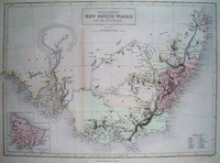
Black and Hughes map of South Eastern Australia shows the extent of exploration and settlement in the region. 'Lake' Torrens in South Australia is shown as if full of water though the note on it…[more]

The World in Hemispheres, with comparitive views of the heights of the principal Mountains and lengths of the principal Rivers on the Globe.
1844
JOHNSTON, A.K
65 x 53 cm

A brilliant later world map that also shows the comparitive heights of the highest mountains and lengths of the longest rivers. From Johnston's 'National Atlas' the map is a fine example of his…[more]

Australia from surveys made by order of the British Government...
1846
ARROWSMITH, John
60 x 83 cm

Reference image of an earlier edition held by the National Library. We hope to have an image of our example shortly.

Arrowsmith's impressive engraved map of Australia issued originally…[more]

New South Wales and Van Diemens Land, Copies or extracts of any correspondance between the secretary of state…on the subject of Convict Discipline not already laid down before the house…
1846
COLONIAL OFFICE, MACONOCHIE, Alexander

Information to…[more]

Australia
Australia
1847
HALL, Sidney
50 x 42 cm

By the late 1840s the extent of exploration of the Australian continent had expanded dramatically. This map illustrates many of the newly explored regions not seen on Johnstons 1844 map of…[more]

New South Wales
New South Wales
1851
TALLIS, John
33 x 25 cm

Information to…[more]

Victoria or Port Phillip
1851
TALLIS, John
33 x 25 cm

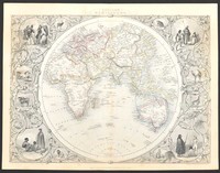
Tallis was best known for his very accurate and visually appealing maps and views, which included most of the countries and many of the colonies of the world at that time. His most accomplished…[more]

Western Australia, Swan River
1851
TALLIS, John
33 x 25 cm

Information to…[more]

Van Diemen's Island or Tasmania
1851
TALLIS, John
33 x 25 cm

Information to…[more]

Australia
Australia
1851
TALLIS, John
33 x 25 cm

Information to…[more]

Part of South Australia
1851
TALLIS, John
33 x 25 cm

Information to…[more]

Eastern Hemisphere
Eastern Hemisphere
1851
TALLIS, John
28 x 36 cm

Tallis' very decorative map of the eastern hemisphere.…[more]

Narrative of the voyage of H.M.S. Rattlesnake...
1852
MACGILLIVRAY, John
23 x 16 cm

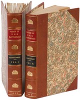
A rare first edition of the exploration of Torres Strait, The Great Barrier Reef, and the coasts of New Guinea during the 1840s by HMS Rattelsnake on their hydrographical voyage as set about by…[more]

Oceanie
Oceanie
1852
LEVASSEUR, Victor
42 x 30 cm

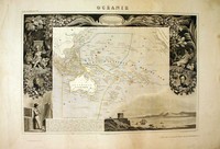
A beautiful map of the Australian region and Pacific. The map is surrounded by a very decorative border depicting scenes from the Pacific.

This map comes from one of the last ornate…[more]