Printed from www.AntiqueMapart.com Catalogue on Friday, May 03 2024
Search Criteria:


Showing Maps 121 to 140 of 245Jump to Page:Next12 ... 56789 ... 1213Next
Plan of Norfolk Island
1793
BRADLEY, William
21 x 23 cm

This early plan of Norfolk by William Bradley shows in some detail the depth soundings around the island. Though the plan does not show much of the Islands interior it does mark the location of…[more]

Chart of the Coast between Botany Bay and Broken Bay Surveyed in 1788 and 89 by Captain John Hunter.
1793
HUNTER, John
73 x 41 cm

This chart by Hunter shows the coastline from Botany Bay to Broken Bay, including Port Jackson. The chart is very detailed and shows the depths to be found in each of the bays.

John…[more]

Des Mers
Des Mers
1793
ANONYMOUS
56 x 32 cm
Information to…[more]
Chart shewing the Track of the Waaksamheyd Transport from Port Jackson in New South Wales to Batavia in 1792
1793
HUNTER, John
25 x 22 cm

An unusual depiction of the Australian continent upside down. Hunter's map of Australia illustrates the voyage of the Waaksamheyd, a dutch vessel, that was used to transport the wrecked crew from…[more]

A General Chart: Exhibiting the Discoveries made by Capt.n James Cook in this and his two preceeding Voyages with the Tracks of the Ships under his Command
1794
FADEN, William, COOK, James
90 x 56 cm

Cook and Roberts' world map was first published in 1784. This edition by Faden was updated to include new discoveries. One of the new discoveries inlcude the inclusion of Lord Howe Island,…[more]

A new & accurate chart of the discoveries of Captn Cook & other later circumnavigators : exhibiting the whole coast of New South Wales, shewing the situations of Port Jackson, & Norfolk Island, where the new settlements are formed…
1794
HOGG, Alexander
32 x 41 cm

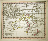
This famous map by Hogg was printed to illustrate the discoveries of eighteenth century exploration in the Pacific. It displays Australia at an important aesthetic period only a few years before…[more]

A New and Correct Map of the World According to the Latest Discoveries
1795
ANONYMOUS
69 x 39 cm

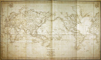
An interesting map of the world, showing discoveries up until 1793. It can be presumed that the map was printed circa 1795. However it is most likely that the map was originally printed in the…[more]

Karte vom Funften Erdthiel oder Polynasien-Inselwelt oder Australien od Sudindien
1795
CANZLER, Fridrich
56 x 45 cm

Information to…[more]

Australien oder Polynesien
1796
SOTZMANN, D.F
32 x 26 cm

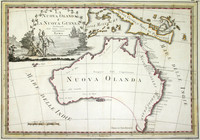
Sotzmann's map of the pacific is a popular German depiction of Australasia. Here Australia can be seen still connected to Tasmania as was believed until Flinder and Bass's discoveries in 1798…[more]

Karte von Australien oder Polynesien: nach den Zeichnungen Reisebeschreibungen, und Tagebucher der vorzuglichsten Seefahrer bis 1789 entwirssen im Jahr 1792, vermehrt 1796
1796
WEIGEL & SCHNEIDERSCHEN
66 x 48 cm

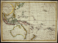
Weigel & Schneider's map of Oceania and the Pacific was a popular depiction and format of the region for many german mapmakers. Their map shows the tracts of James Cook 1st, 2nd, and 3rd voyages,…[more]

Mappemonde ou Carte Reduite des Parties Connves du Globe pour fervir au Voyage de la Perouse fait dans les Annees 1785, 86, 87, 88.
1797
LA PEROUSE
92 x 59 cm

Map of the world showing the route of La Perouse's voyage. Cook's 1770 first voyage discoveries on Australia's East Coast are charted.

Following the immense success of Captain Cook's…[more]

Carte d'une partie du Grand Ocean
1797
LA PEROUSE
49 x 34 cm

Map focusing on the present day Queensland coast, New Guinea, and part of the Pacific. Shown is the 1781 route of Spanish explorer Don Francisco Antonio Maurelle along the northern coast of New…[more]

New Holland with the Adjacent Polynesia
1798
FADEN, William
12 x 10 cm

Faden was the geographer to the King of England and produced many fine works until his death in 1836. This map has three main features that make it especially interesting. 1. this map is one of…[more]

La Nuova Olanda e La Nuova Guinea
1798
CASSINI, Giovanni
48 x 35 cm

Following the much publicised, landmark discovery of Australia's east coast by Captain James Cook in 1770, mapmakers around the world were quick to incorporate those discoveries onto their maps.…[more]

A Chart Shewing the Tract of Capt Cook's Last Voyage
1799
PAYNE
20 x 25 cm

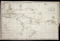
"A Chart Shewing the tract of Capt Cook’s last voyage 1799", by Low. The map shows the route of Cook’s third voyage around the Pacific rim in search of the fabled Northwest passage. On the…[more]

Chart of the Duff's Track in the Pacific Ocean 1797
1799
WILSON, James, CHAPMAN, T
53 x 34 cm

This detailed chart shows the voyage of the Duff in 1797. This map marks and details the route of the first English missionary voyage to the Pacific. Captain James Wilson during the voyage also…[more]

Chart of part of the Fegee ( Fiji ) Islands explored by Cap James Wilson, in the ship Duff…
1799
WILSON, James, CHAPMAN, T
23 x 30 cm
Information to…[more]
No title: Region around Sydney
1802
COLLINS, David
24 x 19 cm

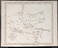
An interesting map of the interior around Sydney. In the early days of the settlement in Australia there was a prime importance to establish sufficient even abundent food supplies so that the…[more]

World
World
1802
DARTON, William
40 x 27 cm

Map of the world showing Van Diemens Land (Tasmania) still connected to Australia, on the map named New Holland. Also in each corner globes showing relevant information. From Walker's Geography.…[more]

New Holland (No title)
1802
ARROWSMITH, Aaron
24 x 20 cm

This interesting map by Aaron Arrowsmith highlights the fact that in 1802 there was little accurate knowledge of the coastlines of the southern portion of the Australian continent. It does…[more]